
What’s better than maps or stamps? Maps on stamps! Call it a peanut butter-meets-jelly moment — when cartophiles and philatelists discover they love the distinct flavor of their disciplines overlapping.
There’s even a club for people who have bitten into this particular nerd sandwich: the CartoPhilatelic Society. They have been around since 1955, but they’re still a lively bunch, with plenty of publications, projects, and events on the calendar.
Maps and stamps do have a few things in common. Both are essentially utilitarian graphics. Both often transcend their original mission to become delightful works of art, communicating a wide range of messages. And both have achieved their “classic” form via the medium of paper, which is why their translation into digital form feels like a threat to their continued existence.

It certainly is a threat to cartophilately. In Germany, the Netherlands, and most Scandinavian countries, you can now e-buy an alphanumeric code, which you can write on your envelope in lieu of a stamp. That does cut down on your trips to the post office. But no more stamps also means no more maps on stamps.
So if you’ve just learned about cartophilately, it’s a field that feels a bit like Rice’s whale — recently discovered, yet already on the brink of extinction. Before it joins the dodo, here are some highlights from Gilad’s Maps on Stamps, a database containing more than 17,500 individual examples from across the world, dating mostly from the 20th century.
Advertising achievements
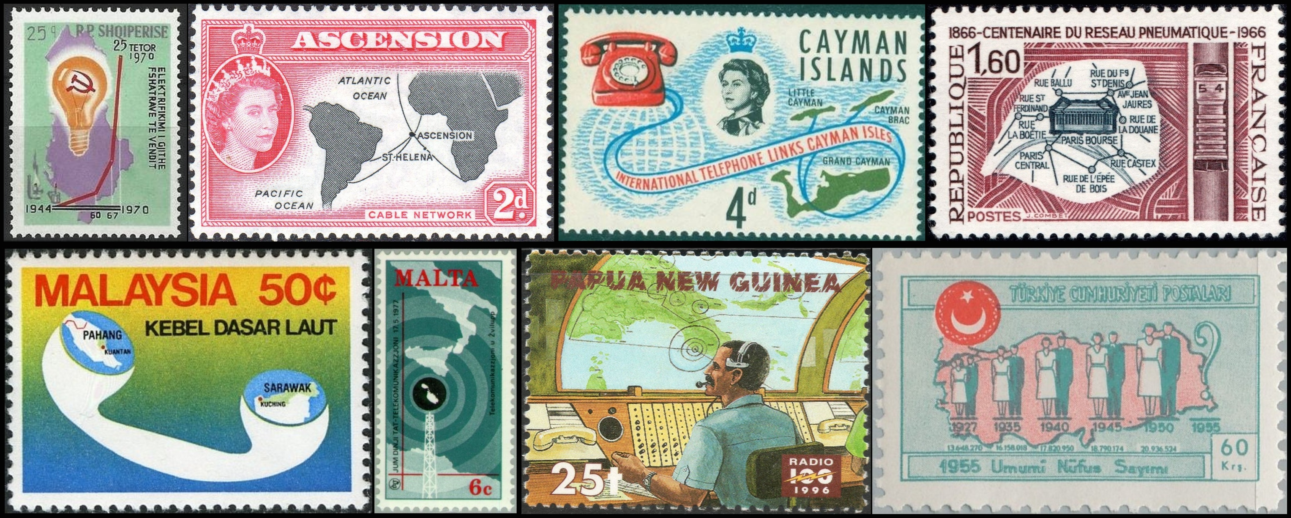
Stamps are a good way to advertise your country’s achievements. See how Albania’s electricity supply shoots up from 1944 to 1970! (Should we be worried about the absence of a y-axis?) Doesn’t the Queen look smug showing off the cables that connect Ascension Island (and on the stamp next to it, the Cayman Islands) to the rest of the world? In 1966, France celebrated the centenary of the Paris pneumatic post. The city-wide system would survive until 1984, when it was killed off by, of all things, the fax.
The stamps from Malaysia, Malta, and Papua New Guinea also focus on communications technology. The one from Turkey celebrates another type of progress: the increase in population size, from 13.4 million in 1927 to 20.9 million in 1950 — and who knows how many when the 1955 census figures come out.
Nothing beats a canal
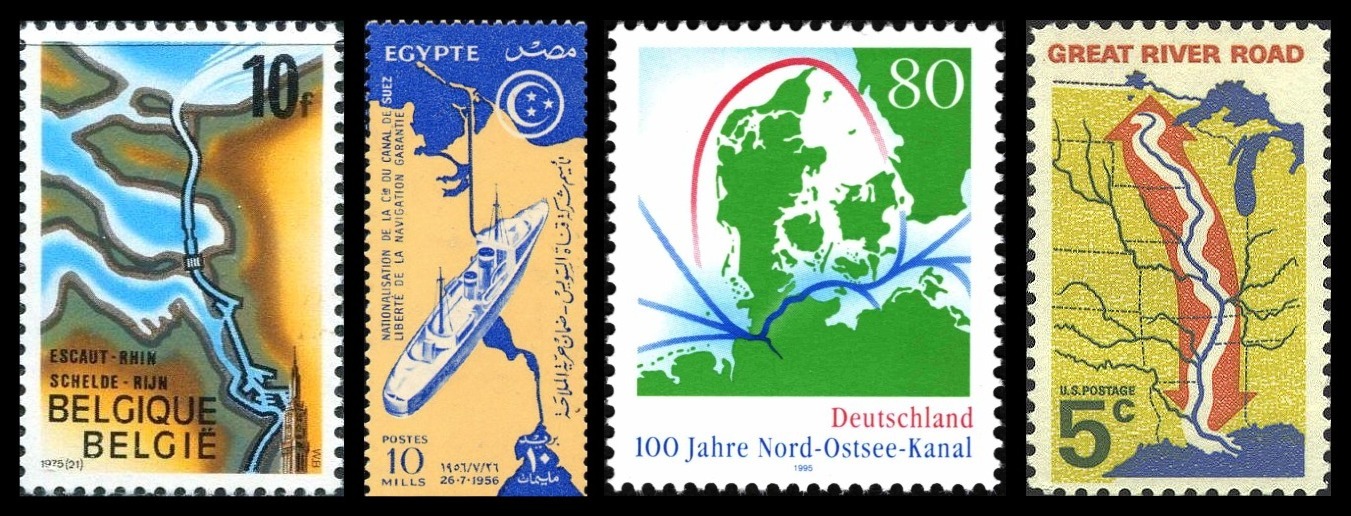
Canals are a favorite marker of progress. Here we have Belgium bragging about the Scheldt-Rhine canal, which links its port of Antwerp to its Dutch competitor Rotterdam. Egypt celebrates the nationalization of the Suez Canal as a guarantee for the freedom of transit. Germany’s stamp shows how the Kiel Canal (a.k.a. the Nord-Ostsee-Kanal) shortens the trip between the North Sea and the Baltic (while also robbing Denmark of its leverage over shipping through the Kattegat). The U.S. stamp is the odd one out. The operating word here is “road,” not “river.” This scenic byway shadowing the Mississippi was first proposed in 1936, but completed well after WWII.
Bragging about airplanes
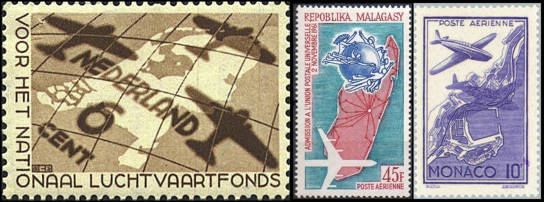
Another recurring theme: aviation. It all goes well together — planes, postage, progress — whether on stamps from the Netherlands, Madagascar, or Monaco. The latter two explicitly celebrate air mail, that distant, winged ancestor of email.
Gimme a slice of that
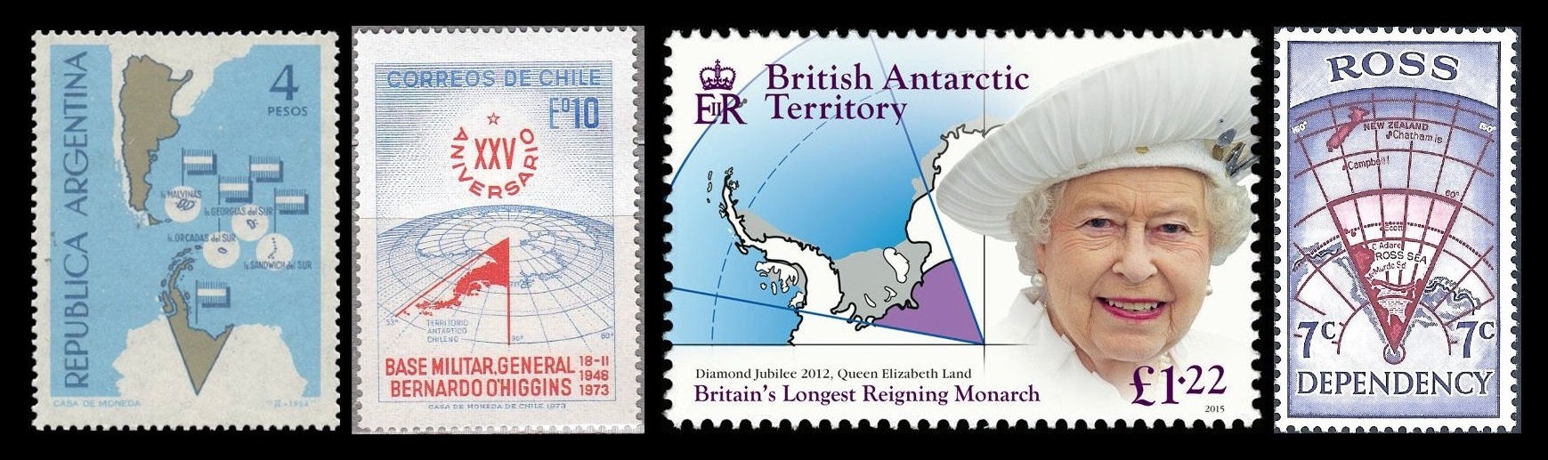
Seven countries maintain territorial claims in the Antarctic. These stamps depict four of those claims by Argentina, Chile, the UK, and New Zealand. (The three other claims are by Australia, France, and Norway.)
The first three stamps illustrate one of the reasons why it’s a good thing all those claims are frozen, as per the Antarctic Treaty of 1959: the British, Chilean, and Argentinian claims overlap. They all include the northward-jutting Antarctic Peninsula, which is the least inhospitable part of the continent. New Zealand has chosen proximity over hospitability and claims a slice of the white continent they call Ross Land, due south of New Zealand itself.
Lick and learn
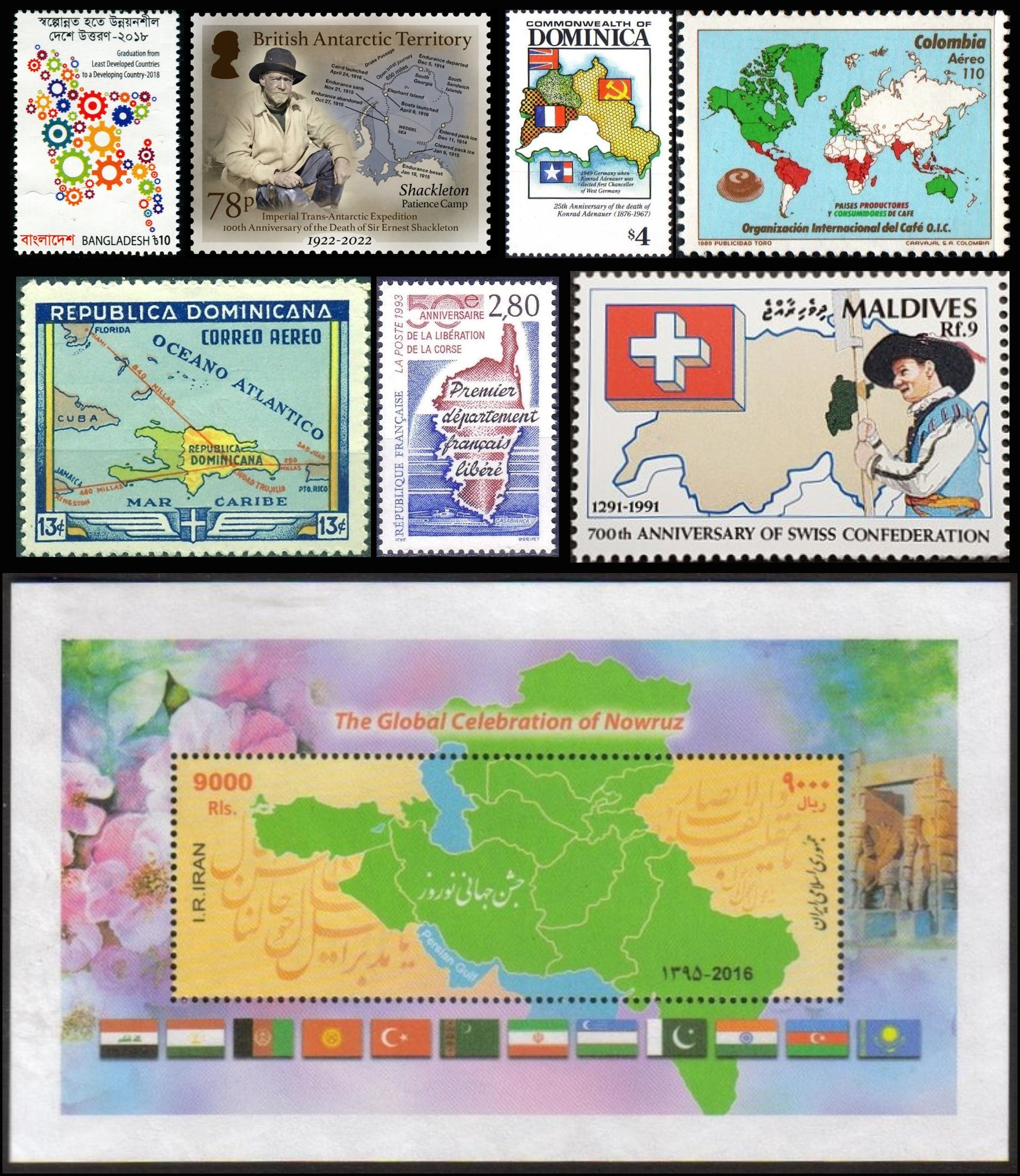
You want to learn something? Lick a stamp. These teach you that in 2018, Bangladesh graduated from “least developed” to “developing” country; which route the British explorer Shackleton took on his “Imperial Trans-Antarctic Expedition” (1914-17); the four occupation zones into which Berlin was divided after World War II; where coffee is mainly produced (in red) and where it is mainly consumed (in green); how far it is by air from Miami to the capital of the Dominican Republic (340 miles); which part of France was first liberated from the Nazis (Corsica, not Normandy!); how small the Swiss confederation was when it began in 1291; and where Nowruz (a.k.a. Persian New Year) is celebrated (in a huge, contiguous zone from Istanbul to Kolkata).
We are here!
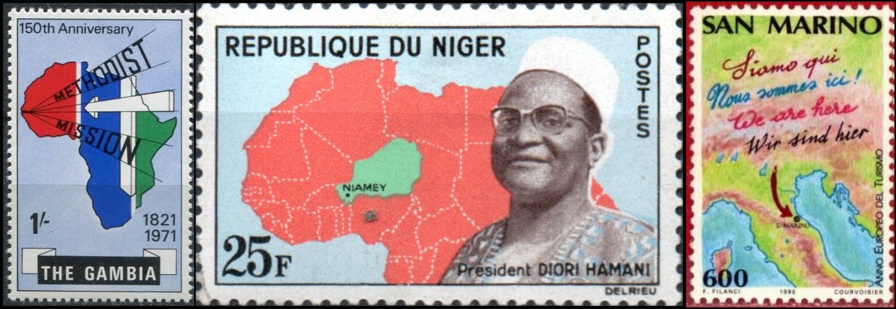
Feeling small and inferior? Well, it happens to entire countries as well — so much so that they feel it is necessary to point out where exactly they are on the map. Stamps are a good way to do just that. You can Gambia on the coast of West Africa and, slightly further east, Niger. (To avoid embarrassment, it’s pronounced nee-ZHAIR.) More than halfway up Italy’s boot, you’ll find San Marino. The tiny Italian republic is the world’s fifth-smallest country and claims to be the world’s oldest state. It was founded in 301 AD by Marinus, the very saint that gave the micronation its name.
That’s ours. Give it back!
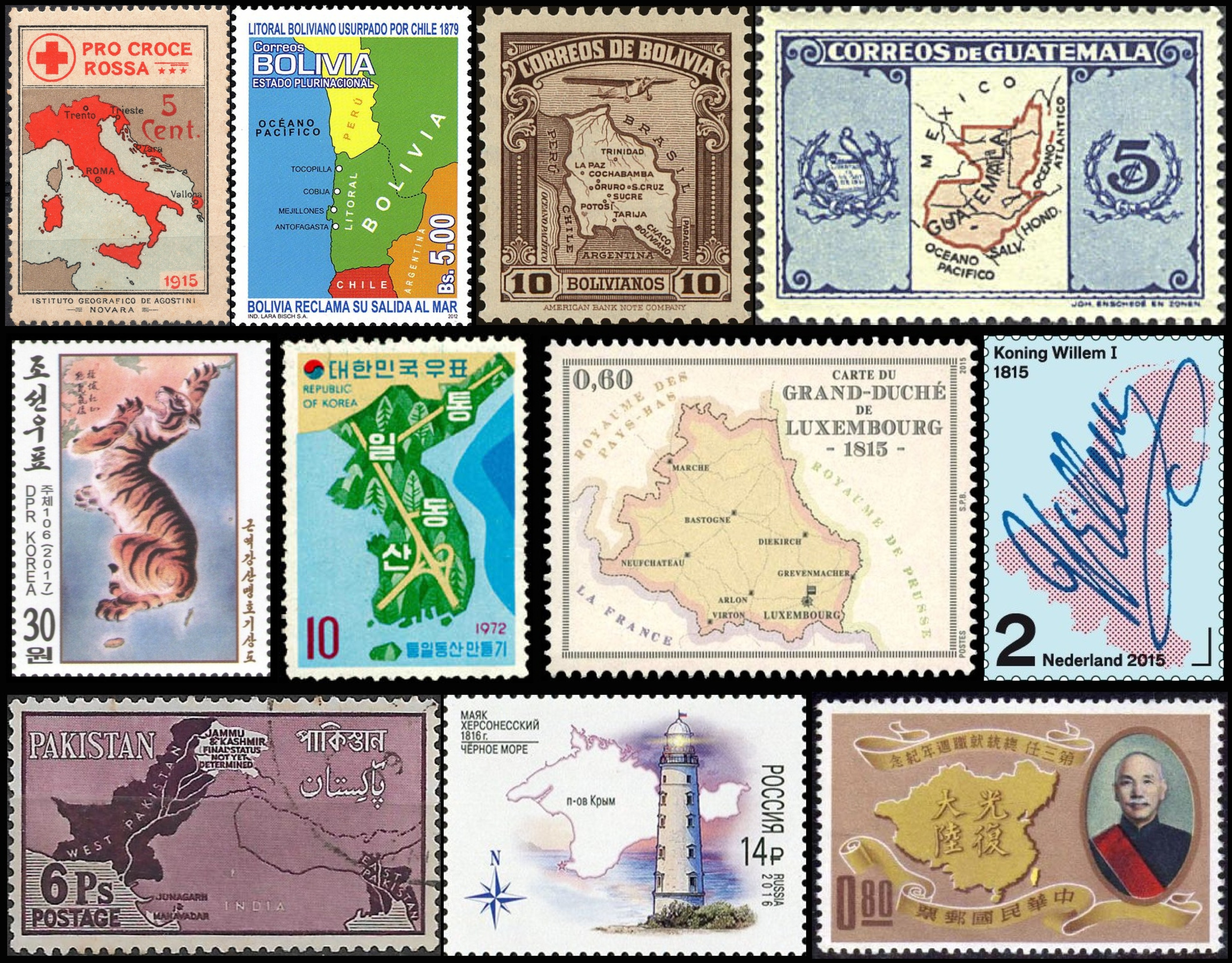
“Irredentism” is when one country looks at parts of another and thinks: That’s ours. Give it back! The term comes from Italia Irredenta (“Unredeemed Italy”), which is what Italian nationalists in the late 19th century called parts of their neighboring countries. The first stamp expresses what the term represented in 1915.
Bolivia lost a lot of wars and, as a result, a lot of territory. Specifically, it lost its access to the coast to Chile (stamp 2) and the largest part of the Chaco region to Paraguay (stamp 3). Guatemala long felt so strongly that Belize should be part of its territory (stamp 4) that it recognized its neighbor’s independence only in 1991.
Both North Korea and South Korea claim to be the rightful government of the whole Korean peninsula, which on the northern stamp turns into a ferocious tiger, and on the southern becomes an idyll of forests and highways.
Luxembourg? Watch out for those fellas. Here they are annexing the eponymous Belgian province, as it appeared in 1815. Two can play at that game, you trilingual freaks. Next, there’s a map of the United Kingdom of the Netherlands, also from 1815, which includes all of “Greater Luxembourg.” Hei elei kuck elei indeed!
The Pakistani stamp says Jammu & Kashmir — final status not yet determined. The stamp predates 1971, when “East Pakistan” became Bangladesh. But even after half a century, India and Pakistan have not yet managed to resolve their dispute over Jammu & Kashmir.
Russia illegally occupied and annexed the Crimean peninsula from Ukraine in 2014. (Nice lighthouse, though.) Taiwan is not just an island off the coast of China. It’s the “other China” and, as such, has a territorial claim on the whole of continental China. And, according to this stamp, a bit more as well — like all of Mongolia.
Stamps of (dis)approval
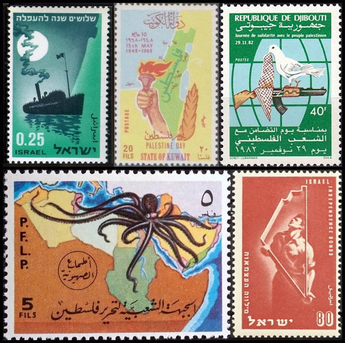
The Holy Land in its current geopolitical definition (Israel plus the Palestinian Territories) has a distinct, dagger-like shape. On Israeli stamps, its coastline serves as a refuge from persecution and a framework for self-determination. On stamps issued by Israel’s hostile neighbors, the same shape becomes a reminder of the Palestinian plight; on the Djiboutian stamp, the shape is represented by the kheffiyeh, the region’s traditional male headdress. The PFLP, a Palestinian terrorist/resistance organization, goes above and beyond. The Israeli state is represented by a many-tentacled cephalopod, its arms reaching all over the Arab world — a recurring trope in propaganda maps (see also Strange Maps #521).
Bigging up the Bahamas
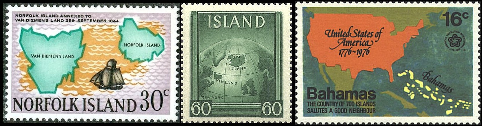
These maps also do political work, but in a slightly more subtle way: by enlarging the country of issue. If it were represented at scale, Norfolk Island almost would be invisible on the first stamp. Iceland definitely isn’t bigger than Ireland and Great Britain put together. And the Bahamas don’t quite stretch that far into the Atlantic. But who needs geographical accuracy when the only victim of your territorial grandiosity is the uncomplaining ocean?
Thumbnail-sized works of art
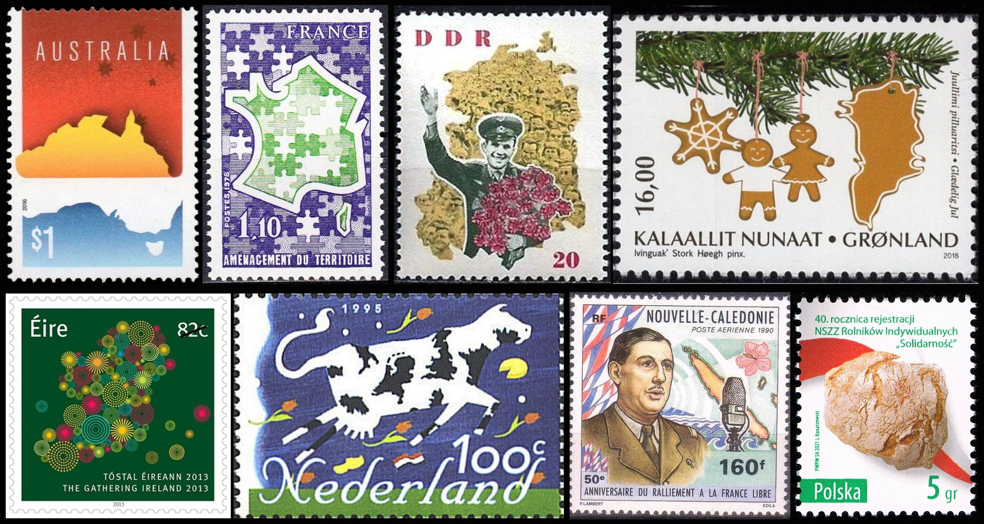
The maps on these stamps don’t covet their neighbor’s land. Instead, they concentrate on being arrestingly beautiful, from a cleverly deconstructed Australia to a Poland disguised as a loaf of bread. If these were the last stamps in your house, you’d send a letter to yourself, just so you could keep them.
Maps and flags on stamps

There’s only one thing better than maps on stamps: maps and flags on stamps! In the top left is a reminder of Afghanistan’s former flag. The next stamp presents two odd couples: the maps and flags of Mali and Japan. The Cypriot example is nicely layered: a map on the flag, the flag on a stamp.
On June 25, 2022, Gabon — despite having been a French rather than a British colony — became the latest member of the Commonwealth. That’s the most remarkable recent thing to happen to this Central African country, which generally manages to stay out of the news. So this is probably the first time you’ve noticed its outline or seen its flag. (You’re welcome!)
Gabon’s neighbor Congo — no, not the DR Congo — and Venezuela put out stamps that celebrated the flags of their continental neighbors, a veritable flag buffet, so to speak. Vietnam cleverly uses the shape of the country to suggest a flagstaff for its banner, while the Zanzibar stamp recalls the national colors of that briefly independent island nation, before it merged with mainland Tanganyika in 1964 to form Tanzania.
Is there more? There is much, much more. Check out about 17,000 other examples at Gilad’s Maps on Stamps. Cartophilately may be endangered, but there’s plenty of history to keep the budding cartophilatelist entertained.
Strange Maps #1187
Got a strange map? Let me know at strangemaps@gmail.com.