Louisiana Flooding: Is This the State’s New, More Accurate Map?

With Louisiana in the grips of dramatic floods that have caused monumental devastation, now is not the time to demand an updated map of the Bayou State.
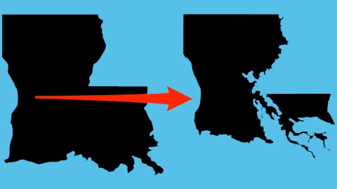
Affecting 20 parishes, the water has claimed the lives of 13 people while chasing tens of thousands from their homes. Rescue and relief are the main concerns now. Yet once the waters have receded (but before complacency sets in again), it’s high time to study the simple, shocking message of this pair of maps.
One map shows Louisiana as its familiar, boot-like self. This is the iconic shape we recognise from countless maps and logos, as recognisable as the shape of, say, Texas, or of the U.S. itself. The other purports to reflect the actual frontline between water land land. On this map, Louisiana is a boot no more. The advancing waters have effectively destroyed the cartographic icon that is, or rather was Louisiana.
The state wrapped around the Mississippi’s delta has been fighting a losing battle against the water for decades now. In the last eighty years, close to 1,900 square miles of land have slipped into the Gulf of Mexico – that’s an area equivalent to the entire state of Rhode Island, plus half a dozen times Washington D.C. Louisiana holds the world record in receding shorelines: on average, one football field every hour is lost to the waves. If nothing is done, another 1,750 square miles will be gone within half a century.

Yet the map of Louisiana has remained reassuringly fixed for as long as anyone can remember. It provides the people perusing it with a false sense of solidity, and security, even as cartographic fiction and geographic fact drift further and further apart.
To bring those two closer together again – and to raise an alarm of sorts – Matter magazine produced a map that shows Louisiana’s true face, unretouched by wishful thinking. To create this map, wetlands and other areas that commonly appear as land on government-issue maps were recategorised as water. The result is nothing less than shocking: that old familiar Boot has been shrunk and shredded.
Although Matter admits that its map may not be perfect either, it argues that it is closer to the actual truth on the ground – or lack of it – than Louisiana’s hitherto accepted cartography, which has held on to old coastlines even as the wetlands behind them have become increasingly wet, and less and less land.
And while adopting this newer, wetter map of Louisiana in and of itself will not change the rising of the waters and/or the sinking of the land, it would turn the spotlight firmly on a problem that is so huge and scary that it is more easily ignored than acted upon: the slow, but continuous erosion of the very matter that makes up the state of Louisiana.
For more on Louisiana’s coastal erosion, the deceptiveness of the state’s current cartography and the efforts to remap its shoreline, see the original article in Matter.
—
Strange Maps #797
Got a strange map? Let me know atstrangemaps@gmail.com.


