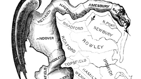
This First Map of a Gerrymander Will Make You Angry

The painter Gilbert Stuart was inspired by the awkward shape of an electoral district on a map he saw in a newspaper editor’s office. He decorated the snake-shaped district with a head, a set of wings and claws, making it out to be some kind of antediluvian monster. “That will do for a salamander,” he said to the editor. “Gerrymander!”, replied he to Stuart.
For the man responsible for the odd shape of that electoral district, in eastern Massachusetts, was Elbridge Gerry, governor of the state. His Democratic-Republican partisans had stitched together the district in such a way as to assure the electoral victory of their candidate and therefore the defeat of the candidate for the other main party, the Federalists. The year was 1812, and the first of many recorded uses of the term occurred that spring.

The continued popularity of the term – and relevance up to the present day – stems from the practice in the United States of revising the boundaries of electoral districts every 10 years, in order to keep up with demographic change. A very wise provision, and many of those districts do in fact change, but not always with the accurate representation of the electorate in mind.
In fact very often the redistrictings perversely reflect the attempts of one party or another to gain a ‘safe’ seat, in which the other side can’t win. Legal maybe, but hardly very democratic. The term is also relevant in the United Kingdom, as in other countries that elect their officials via the ‘first past the post’ system. Gerrymandering is less relevant in countries with a system which emphasises proportional representation.
This cartoon dates from 1812, and depicts the very first ‘gerrymander’ – if you’re a stickler for historical accuracy, please pronounce with a hard g, just like the name of the governor. The word has since been in use as a verb and a noun, depicting the action of redistricting with intent of political gain, as well as the resultant unlikely-shaped district.
—
Strange Maps #53
Got a strange map? Let me know atstrangemaps@gmail.com.
Map here at Wikimedia Commons.


