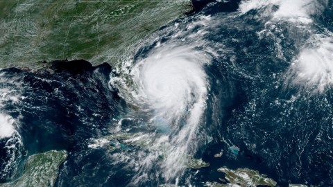
Hurricane Dorian: Why are more extreme storms stalling?

Image: NASA
- Hurricane Dorian is one of the strongest Atlantic hurricanes on record, with wind speeds of more than 200 mph.
- The storm was moving slowly over the Bahamas as a result of clashing high- and low-pressure systems.
- It’s unclear whether climate change is causing shifts in large-scale wind patterns, but scientists generally agree that warmer temperatures are causing storms to become stronger.
Hurricane Dorian became on Sunday the strongest hurricane to ever hit the Bahamas, pummelling islands with 200-mph winds and more than 20 feet of coastal flooding. At its strongest point, the Category 5 storm — the most severe ranking — floated nearly motionless over the islands, inching along at about 1 mph as it dropped more than 2 feet of rain. At least five people in the Bahamas were killed by the storm.
By Monday, Dorian was a Category 4 storm. On Tuesday, the slow-moving hurricane had lost much of its steam and was downranked to Category 2. But Dorian has grown in size if not force, and it’s expected to move northerly over the Atlantic, parallel with the coast of Florida and, later, Georgia and the Carolinas. Violent winds have already struck parts of Florida, and officials in multiple states have already ordered thousands of residents to evacuate.
“I can’t decide for you, but I’m asking you, as the mayor of Savannah: Please attempt to get out of town as best you can, and come back in a few days and begin your life over and move forward,” Eddie DeLoach, mayor of Savannah, Georgia, said in a public appearance Monday night, according to The Savannah Morning News.
For now, the main focus of residents and officials in the storm’s path is safety, rescue and, eventually, reconstruction. But for scientists who study storms and climate change, Dorian’s intensity and brutal sluggishness highlight how warming temperatures are changing the nature of extreme storms around the globe.
A pattern of stalling hurricanes
In recent years, scientists have identified a pattern: Severe hurricanes are not only becoming stronger and more common, but many are also moving more slowly and even stalling, as Hurricane Harvey did over Houston for days in 2017, dumping 60 inches of rain in the process. A study published in June by NASA and NOAA scientists showed that the average forward speed of North Atlantic hurricanes has slowed from 11.5 mph in 1944 to 9.6 mph in 2017.
So, is climate change making hurricanes slower? It’s too early to say for sure, and the issue is still an area of debate among climate scientists. In the case of Dorian, the violent storm stalled above the Bahamas because, somewhat ironically, the atmosphere was too calm; a clash between high- and low-pressure systems caused the weather pattern to come to a standstill.
But scientists generally believe that warmer temperatures in the Arctic are likely playing a part in slowing down wind patterns, as NOAA hurricane expert Jim Kossin, co-author of the June study, told InsideClimate News:
“…in the broadest sense, global warming makes the global atmospheric circulation slow down,” he said. “There is a lot of evidence to suggest this is more than just natural variability.”
How exactly warmer temperatures affect wind patterns is a complicated issue that needs further research. But there’s little debate among climate scientists as to whether climate change is making storms worse and more common.
“The environment for all such storms has changed because of climate change,” Kevin Trenberth, a climate scientist with the National Center for Atmospheric Research, told Inside ClimateNews. “The oceans are warmer, especially in the upper 100 meters, which is most important for such storms,” Trenberth said. “This makes available more energy via water vapor for the storms and makes for more activity: more intensity, bigger and longer lasting storms, with heavier rainfalls.”


