Monday Musings: Etna’s ash, mapping Kilauea deformation, Auckland’s new volcano and more

I’m as surprised as you are, but it is already Monday. Busy week for me – students getting ready to register for Fall Semester courses and a talk to give at the end of the week … but at least we get to watch “In the Path of a Killer Volcano” (about the 1991 eruption of Pinatubo) in my freshman volcanoes class. That documentary is probably my favorite all-time, definitely worth checking out if you want to see front line volcanologists at work.
(UPDATE: Commenting seems to work again. Thanks to the tech folks here for figuring it out!)
Some news:
Etna: Dr. Boris Behncke has been keeping us appraised on the fits and spurts at Sicily’s volcano. We haven’t seen a return to the spectacular eruptions of January 2011, but there have been small ash emissions over the past few days from the southeast crater, which could suggest that more activity is in the works. Looks like we need to keep an eye on the volcano. However, March was a quiet month for both Etna and Stromboli.
Kilauea: The Hawaiian volcano will get the InSAR treatment over the next week from a NASA aircraft. InSAR is a method of using radar to look at changes in the surface of the Earth by comparing two images taken during different periods and then comparing the two images. By seeing where they are different, you can determine how much potential uplift/deflation might have occurred (if you’re examining a volcano). Kilauea was last imaged in January of this year, so these new flights will hopefully be able to see minute changes in the volcano since the March Kamoamoa Fissure. The latest Kilauea update reports that the volcano is inflating near the summit crater while activity at Pu`u O`o appears to be sporadic with weak deflation.
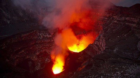
Ambrym: NASA also released an image of ash and volcanic gases from Ambrym volcano in Vanuatu spreading out over the Pacific. Ambrym is one of the more active volcanoes in the Southern Pacific island chain with an active lava lake (top left) – and made famous last year by this video.

DEVORA (DEterming VOlcanic Risk in Auckland) logo. Kind of reminds me of this.
Auckland: It always amazes me how little people know about their surroundings – which is why, whenever I see news from New Zealand about Auckland’s volcanic past (and present), it seems to be treated with such shock in the media. Yes, the city of Auckland is built upon the Auckland Volcanic Field, which has been quiet as of late, but doesn’t mean it will always stay that way. The latest article mentions the identification of another volcano under the city – the Grafton volcano – which appears to have last been active 50,000 years ago (although that number could change). All of this research is part of the DEVORA project (which might have the best logo ever – see top left) to fully characterize the volcanism present in the geologic record around New Zealand’s largest city.
Iceland: Volcanic activity has been pretty quiet in Iceland lately. That hasn’t stopped Jón Frímann from being busy – he recently posted what could only be called the “Cliff Notes” for Icelandic eruption. Check it out to see how active the island has been over the ~1,200 years.
Top left: Undated image of the crater at Ambrym, Vanuatu.


