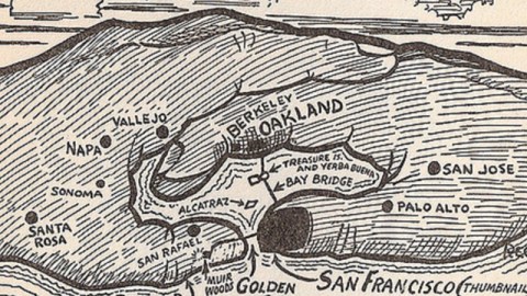
A Handy Map of San Francisco Bay

The metropolitan area surrounding San Francisco Bay, better known as the Bay Area, includes over 100 cities (San Francisco, Oakland and San José being among the most populous) and counts about 7 million people. It is the 4th-largest metropolitan area in the US and the 47th-largest in the world.
Many non-locals will be surprised to learn that San José is the largest city in the Bay Area (having surpassed San Francisco in the 1980s). Another lesser-known fact is that a map of the entire Bay Area can be created using nothing more than two functioning, interlocking hands (preferably your own).

This ‘Handy Map of San Francisco’ does not say why or whether it is absolutely necessary to paint your right thumbnail black to create the effect of San Francisco. For other manual maps, see also Michigan (#454) and Santa Cruz (#512).
Many thanks to Adam Koford for sending in this map, found in a 1938 Cartoon Guide to California by Reg Manning.
Strange Maps #313
Got a strange map? Let me know at strangemaps@gmail.com.


