Eyjafjallajökull Update for 5/11/2010
Ash from Eyjafjallajökull is now closing airports as far south as Morocco while the eruption chugs on with little sign of an end.
Sign up for Big Think on Substack
The most surprising and impactful new stories delivered to your inbox every week, for free.
I an in the home stretch for grading exams, so just a quick update for today:
nn

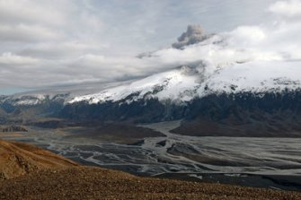
nThe evidence of floods from the Eyjafjallajökull eruption, taken on May 1, 2010 by Dr. Joe Licciardi.
nn
- n
- Airports now as far south as Spain, Morocco and the Canary Islands are facing closures due to the Eyjafjallajökull ash. The latest London VAAC ash advisory has the ash wrapping around western and southern Europe, which I am sure is making life interesting for routing transatlantic flights into Europe. The flights within Europe don’t seem to be that effected according to Eurocontrol – and they have even dropped the “buffer zones” around the ash, saying that the models are good enough to predict exactly where the ash will be (let the wailing and gnashing of teeth commence).
- As for the eruption itself, there has been seismicity at depths of 18-20 km under the volcano, but the style of eruption has not changed that much over the last few days. There is some suggestion by geophysicist Steinunn Jakobsdottir that these new quakes might signal the start of a new vent, but that is only speculation at this point. The latest Iceland Met Office update reports that the light gray eruption plume reaches ~5-6 km (17,000-20,000 feet)) but sometimes it shoots up to 6 km (20,000 ft). Ashfall in Iceland has become continuous in some parts, with 2-3 mm lapilli falling at farms in Drangshlíð and Skarðshlíð just south of the eruption. You can check out the excellent timelapse video of some of the activity from the FLIR thermal camera or the webcam as well. And, if you’re really curious about the Eyjafjallajökull-Katla connection, you can check out the figure put together by the Chicago Tribune that isn’t half bad (minus a few liberties in terms of the magmatic plumbing).
- One positive side of this eruption and the oil spill in the Gulf of Mexico might be an increased awareness of hazard planning. However, as with any disaster, the perceived threats lasts only as long as people’s memories of the event.
n
n
n
nn
{Hat tip to all Eruptions readers who helped provide links for this post!}
Sign up for Big Think on Substack
The most surprising and impactful new stories delivered to your inbox every week, for free.


