It’s incredibly simple and straightforward, and the science doesn’t lie. (And yes, global warming played a role!)
“The hurricane flooded me out of a lot of memorabilia, but it can’t flood out the memories.” – Tom Dempsey
No hurricane, typhoon, or tropical storm, in all of recorded history, has dropped as much water on a single major city as Hurricane Harvey just did in Houston, TX. The National Weather Service has had to create a new scale to accurately depict how much rain has fallen, as a few locations have crested the three foot mark, as of a week ago, since the Hurricane first made landfall. Things weren’t done even then, as the eye of the storm took up residence right off of the Texas coast, and large swaths of the southwest continued to experience unprecedented, heavy rains all throughout the week. While many weather professionals are calling this a “500-year-storm,” indicating that there’s only a 0.2% of a storm like this happening in a given year, the science of how a storm like this occurs is actually very straightforward.

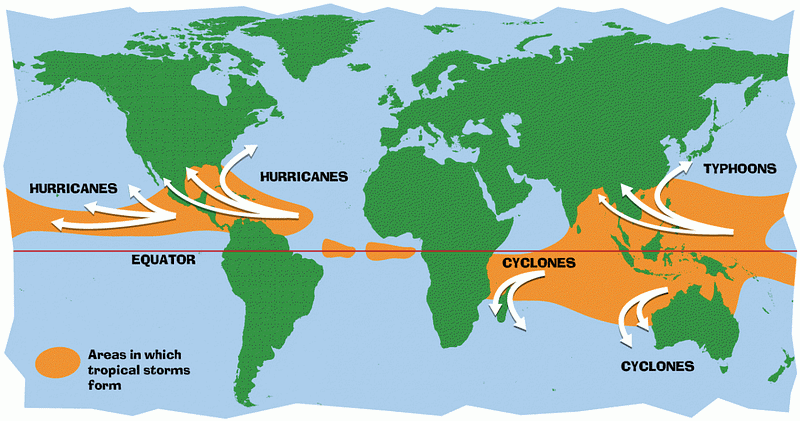
All you need is warm ocean water and wind, and a few key ingredients can come together to create a tropical storm. There’s a reason that such storms (e.g., cyclones, hurricanes, typhoons) always form over equatorial regions: that’s where the warmest ocean water is located. When wind blows over that warm ocean water, it picks up not only heat but also moisture from the ocean. Water has more heat capacity and is far denser than air, so when the ocean is warmer than the air, it heats it up very efficiently, and causes it to rise. As it rises, it cools, which means the water-containing air will then form clouds. This is a straightforward phenomenon, but it isn’t enough to make a hurricane on its own.

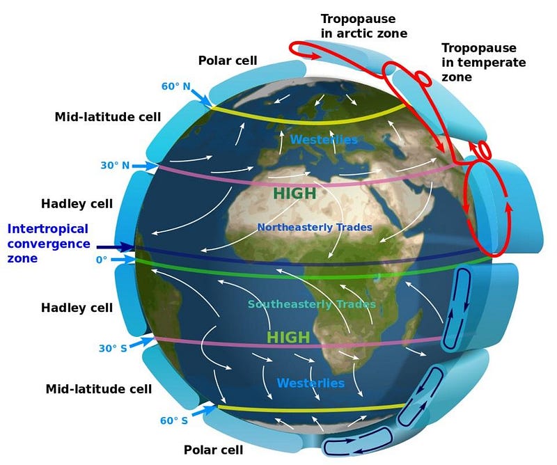
The warmer the ocean water is, the easier it is for that moisture-rich air to rise, cool, and provide ongoing fuel for a storm. In order to make a tropical cyclone, you need that water to be at least 80º F (27º C) for the first 50 meters (165 feet) of its depth. This is why tropical storms like hurricanes, typhoons and cyclones only form along the equatorial regions of the world; you need that warm, deep ocean water. But you also need something else: fast-moving winds. Between about 30º N and 30º S of the equator, where the water is warm enough to give rise to tropical storms, the Earth’s prevailing winds circulate from east to west, with northern latitudes seeing winds that blow southwest and southern latitudes having winds that blow northwest. These winds, combined with the warm temperatures, are key for creating hurricanes.

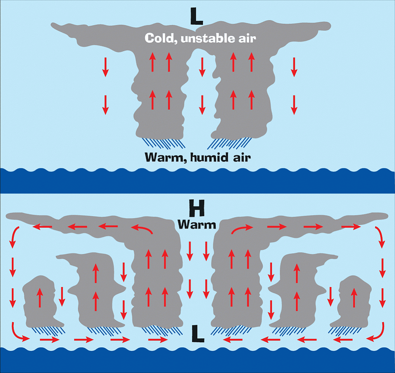
Where you have fast-moving winds over the warm ocean, the air heats up, absorbs moisture, and rises. The warmer the water and the faster the air just above the surface moves, the faster the water evaporates, turns into water vapor, and then rises. The air and the vapor within it cool as the air rises, and eventually the vapor condenses back into clouds. Where there’s lots of moving air over warm water, there’s lots of moisture rising, and hence, thicker clouds. These cumulonimbus clouds (or, more commonly, rain clouds) will “stack” on top of one another, rising higher and higher, creating the origins of a tropical disturbance.

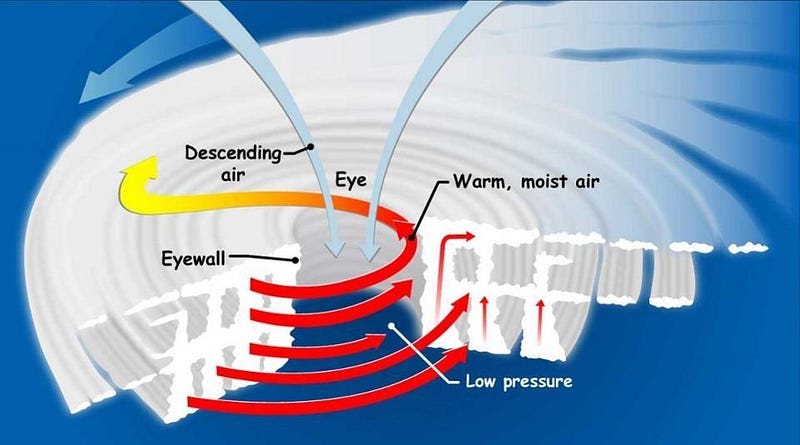
Most disturbances don’t turn into hurricanes, but some will. If the rising warm air is then pulled into the column of clouds, while the air at the top cools, the high-altitude air can become unstable, forcing it to sink again. But it may not be able to sink fast enough. If not, the cooling water vapor releases heat, making the cloud-tops warmer, raising the air pressure and causing winds to blow outwards from the center. Finally, the cool air will fall, but this low-pressure area makes it easy for the water at the surface to evaporate and rise, creating more clouds and a larger rising, stacking area. As winds in the column start to spin faster and faster, a tropical depression, tropical storm or even a full-fledged tropical cyclone (i.e., a hurricane) can form. And so long as it remains over this warm, liquid ocean, it can continue to strengthen.

The worst-case scenario for a storm is where it develops in the ocean, strengthens as it moves over land, and then migrates to make landfall right where the directions of the prevailing winds change: at around 30 degrees latitude. The greatest flooding and devastation occurs when the storm either remains stationary, right on a coastal area for a long time, or when it moves along a coastal region, constantly being fed by the ocean waters as it does so. Houston, Texas, is located right at 29.8° N latitude, right by the gulf coast; it is at the right location, unfortunately, to experience this perfect type of storm. This real-time wind map of the United States shows how dire the situation is, as does the embedded video (below) from the National Weather Service.
Updated radar animation for #Harvey that includes the last 24 hours. The animation runs from 7 pm CDT Thu 8/24 to 1130 am CDT Mon 8/28. pic.twitter.com/yBGGXnVwCj
— NWS Eastern Region (@NWSEastern) August 28, 2017
As you can see, the combination of the unusually warm water, the fact that Houston (and the hurricane’s eye) are right on the border of where the prevailing winds change directions from east-to-west to west-to-east, and the water-to-land boundary along the gulf coast has created the exact recipe needed for this unfolding catastrophe. Things didn’t get better anytime soon, either. According to the NOAA National Hurricane Center:
Harvey is expected to produce additional rainfall accumulations of 15 to 25 inches through Friday over the middle and upper Texas coast, including the Houston/Galveston metropolitan area. Isolated storm totals may reach 50 inches in this region. These rains are currently producing catastrophic and life-threatening flooding, and flash flood emergencies are in effect for portions of southeastern Texas.
It wound up delivering over four feet of water to parts of Houston. Yes, climate change likely played a role in this event, as fewer, more intense hurricanes, coupled with sea level rise, are being borne out, exactly as predicted. Unfortunately, this likely means that “once every 500 years” is likely to be very wrong, as the Hurricane Katrinas, Sandys, and Harveys of this world are only going to become more common moving forward.
Ethan Siegel is the author of Beyond the Galaxy and Treknology. You can pre-order his third book, currently in development: the Encyclopaedia Cosmologica.
